At the very beginning
Edo Castle was founded by Ota Dokan (大田道灌) in 1457.
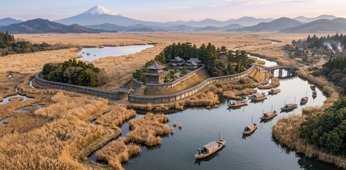
Joshoken (静勝軒), where Ota Dokan lived, was located at the site of the current Fujimi-Yagura Watchtower (富士見櫓) in the East Gardens of the Imperial Palace (皇居東御苑).

“The Preface to the Poem on Edo Castle’s Joshoken (寄題江戸城静勝軒詩序),” which Dokan had Ryuto (竜統)—a Zen monk from Kennin-ji Temple in Kyoto—write, and the “Inscription and Preface for Joshoken (静勝軒銘詩並序),” written by a monk named Banri Shukyu (万里集九), were once hung under the eaves of Joshoken. Since these documents have been preserved to this day, we can understand the state of Edo Castle back then to a considerable degree.
Joshoken was a three-story structure with windows on all four sides of each floor, modeled after Kinkaku-ji in Kyoto. Joshoken was described as follows: “To the northwest lie Mount Fuji and the Musashino Plain; to the southeast lie the Sumida River and Mount Tsukuba. Truly, the views of all four directions can be enjoyed from this single castle.”
As for the castle layout, in addition to the nejo (子城 or 根城, the core stronghold, or honmaru [main compound]), it connected three compounds in a row together with the nakajo (中城, middle compound) and tojo (外城 outer compound). They were linked by drawbridges (飛び橋 tobibashi)—bridges that could be pulled up in the event of an enemy attack to prevent passage.
While building multiple outlying castles or forts around a main compound had been seen since ancient times in mountain castles constructed along peaks and ridges, this method—linking multiple compounds together on flatlands or hilltops to create a complex structure where the remaining compounds could repel the enemy even if one fell—is said to have been pioneered by Sukenaga (Dokan) at Edo Castle. This castle-building technique became known as Dokan-gakari.
During the era when Tokugawa Ieyasu entered Edo, the moats between these three compounds were all filled in, turning them into a single, continuous main compound (honmaru). Today, this area has become the open lawn of the East Gardens, containing the ruins of the castle keep and the Fujimi-yagura Keep.
From the north-to-south elongated shape of the current honmaru ruins, it can be inferred that the three compounds were arranged in a single vertical line. As for the elevation, the west and south were high, while the north and east were depressed.
One break between the compounds was likely at the Shiomi-zaka Slope. Another was likely at the slope leading to the Chujaku-mon Gate.
There were twenty-five stone gates; the slopes leading up to the castle were stone steps, the hedges were built of stacked stone, and the water level of the five or six wells inside the castle remained unchanged even during prolonged droughts. The “stone steps” likely referred to Bairin-zaka Slope and Shiomi-zaka Slope.
The northern compound at the top of Bairin-zaka Slope was the tojo (outer compound). The southernmost compound, located deepest within, was the nejo. The one in the middle was the nakajo. However, it is possible that the positions of the tojo and nejo were reversed.
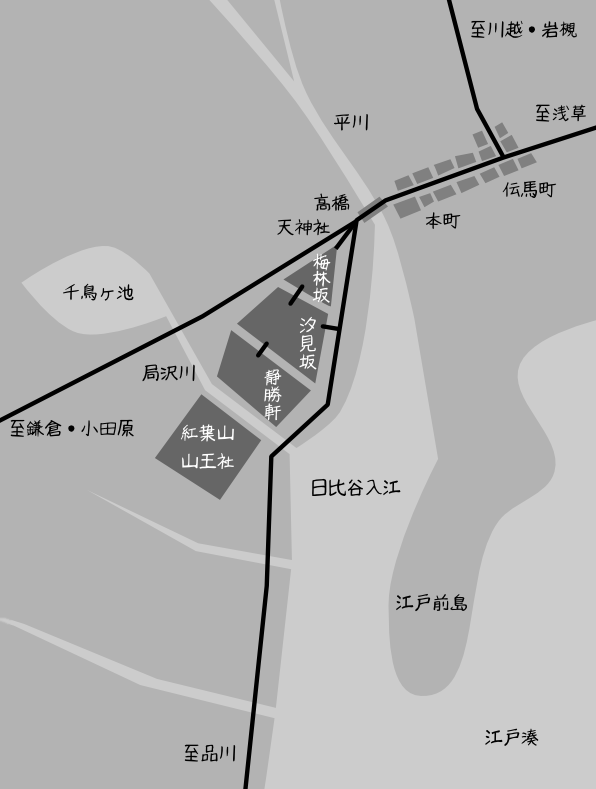
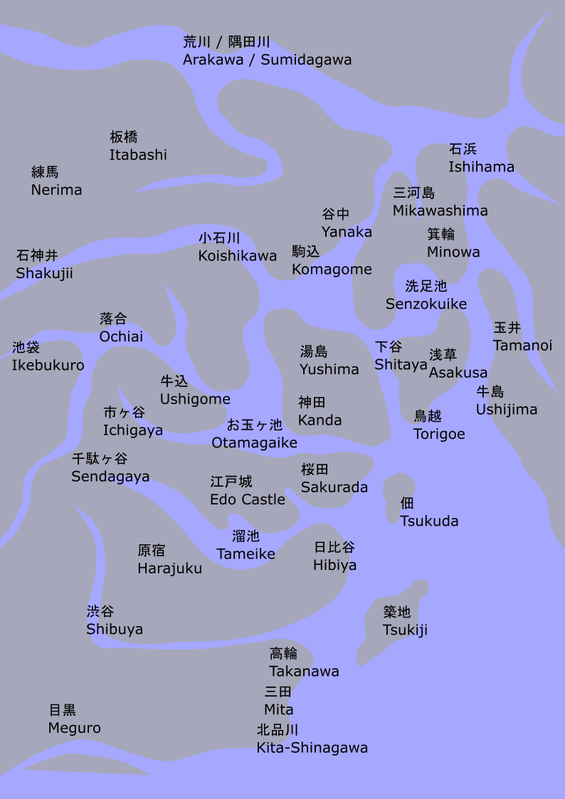
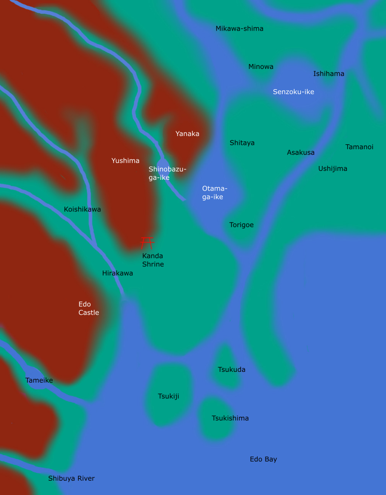
A river called the Hirakawa flowed from the north to the east of the castle, curving clockwise before emptying into an inlet. In the past, Hibiya was sea, to the east of which lay Edo Maejima, and to the east of that was the estuary of the Sumida River, known as Edo Port.
Where the Otemachi of that era—that is, the front entrance of the castle—was located is determined by where the Hirakawa originally flowed and how far the Hibiya Bay extended. The sea of Hibiya extended all the way to the bottom of the slope now called Shiomi-zaka, which descends from the middle of the East Gardens to the east side.
Regarding the origin of the name Shiomi-zaka, it is said to mean “a slope for viewing Edo Port in the distance,” but that is likely incorrect. For that purpose, the top of the slope would have been more suitable. It is more likely that one could observe the ebb and flow of the tide (shiomi) in the Hibiya Sea from the bottom of the slope.
Joshoken was located at the southernmost tip of the plateau that formed the three compounds—at the current site of the Fujimi-yagura Keep. Judging from the difference in elevation, it was indeed atop a cliff. Even today, it sits above the stone walls to the north of the Imperial Palace Outer Gardens, but back then, the view must have been truly magnificent.
There were also several other keeps, as well as Hakusentei (“Boating Pavilion”) to the east overlooking the Hibiya inlet, and Gansekitei (“Snow-Snow-Capped Mountain Pavilion”) to the west facing Mount Fuji. “Hakusen” and “Ganseki” were derived from Du Fu’s poem:
Two yellow orioles sing in the green willows, 両箇黄鸝鳴翠柳
A line of white egrets mounts the blue sky. 一行白鷺上青天
The window frames the western peak’s thousand-year snow, 窗含西嶺千秋雪
The gate moors the boats from Ten Thousand Li of Eastern Wu. 門泊東呉萬里船
Additionally, “Josho” (静勝 quiet victory) is said to come from the line “A military wins through composure; a nation wins through focus 兵以静勝、国以専勝” in the ancient Chinese military treatise Wuzi (尉繚子 Yutiaozi).
Gansekitei was likely at the western edge of the southern compound. Looking out from there, one would have seen a vast, boundless grassland beyond Chidorigafuchi, the plateau of the Kanto Loam layer, and Mount Fuji far beyond that.
A river called the Tsubone-sawa River (局沢 or 坪根沢) flowed out from Chidorigafuchi. This is the remnant of today’s Hasuike-bori Moat, which emptied into the Hibiya inlet around the Hamaguri-bori Moat, beneath the Fujimi-yagura Keep.
In other words, the original Edo Castle stood atop a cliff at the tip of a long, narrow tongue-like peninsula that extended from the Tayasu Plateau into the Hibiya inlet, sandwiched between the Hirakawa River and the Tsubone-sawa River.
The Ote-bori and Kikyo-bori Moats were on the eastern shore of the Hibiya inlet. The Tenjin-bori and Hakucho-bori Moats are the remnants of the cliffs on the west side of the inlet, and the Ninomaru and Sannomaru compounds were at the innermost part of the former Hibiya Bay. The structure called Hakusentei (泊船亭 i.e., boathouse) was likely atop the cliff at Hakucho-bori— where many ships must have been moored in the inlet below it.
The Tenjin-bori Moat is now a very short, blind-alley-like moat located right after descending Bairin-zaka Slope. As its name implies, a Tenjin shrine was once enshrined on its banks. Plum blossoms are naturally associated with Tenjin. The plum trees of Bairin-zaka Slope are said to have existed alongside the shrine since Dokan’s time, but only the shrine was later relocated toward Kojimachi, becoming today’s Hirakawa Tenmangu Shrine.
The area around Tenjin-bori at the bottom of Bairin-zaka Slope was likely the main gate (Otemon) of the castle at the time. It faced east, with the mouth of the Hirakawa River right in front of it, spanned by a bridge named “Takahashi.” On the other hand, there was likely a landing site (a river port) at the bottom of Shiomi-zaka Slope as well.
There is no doubt that going down Bairin-zaka, crossing the Hirakawa River via Takahashi, and heading east—the area from Honcho (本町) to Denmacho (伝馬町)—was a major transportation hub for Edo. In fact, one could even say that these town names reflect the ancient, pre-Ieyasu state of Edo. The road heading toward Kawagoe must also have branched off from around Honcho and extended northward even back then.
Mitsuke 見附
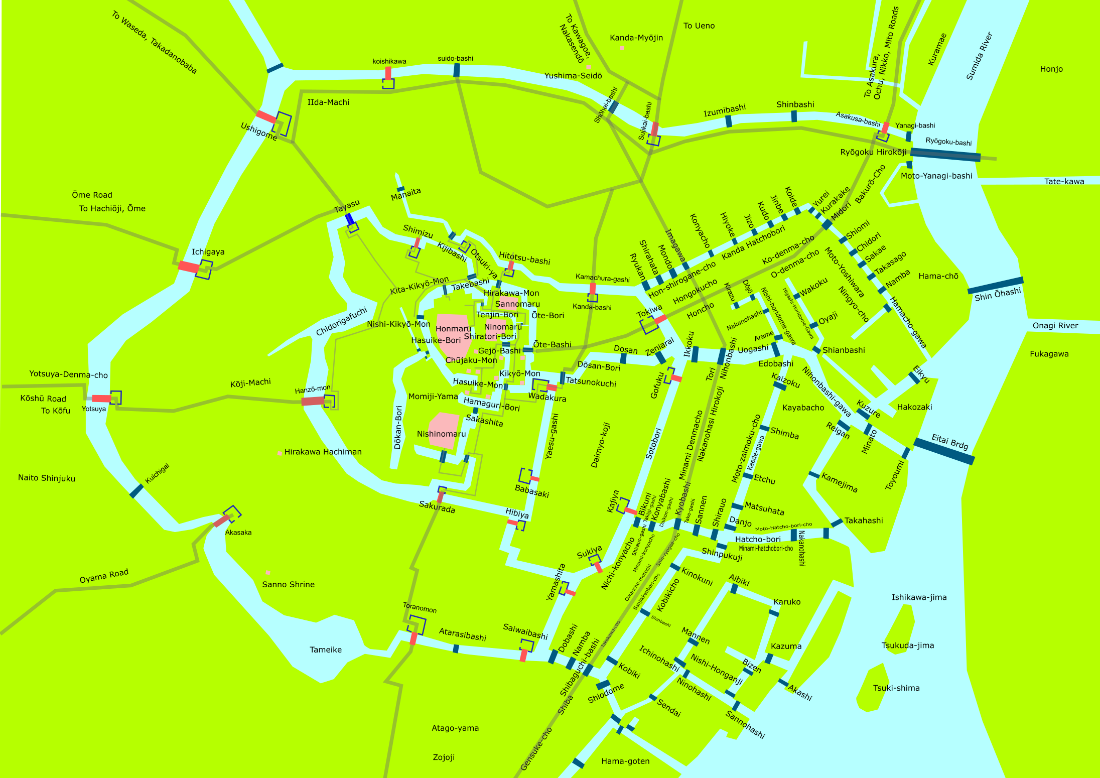
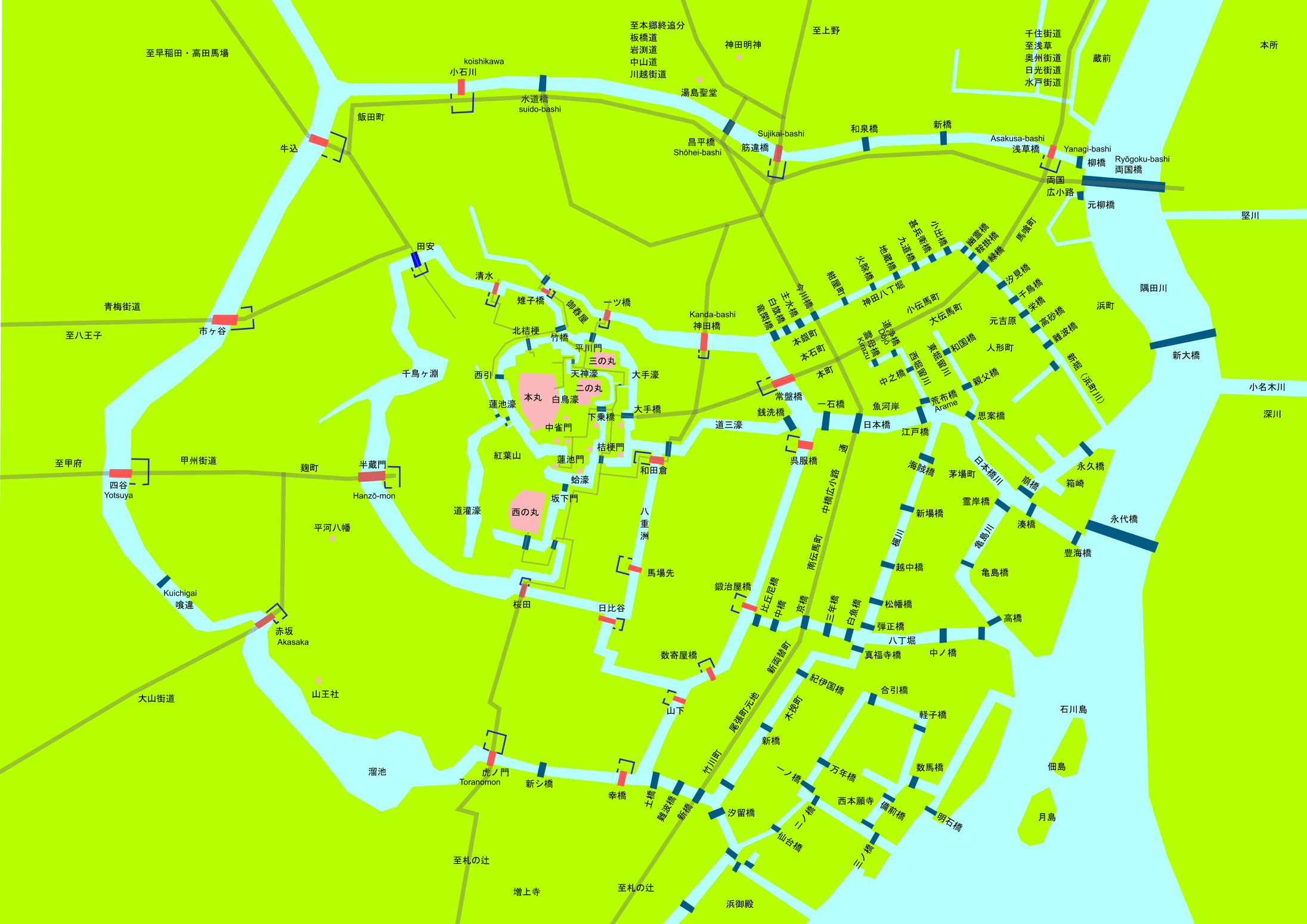
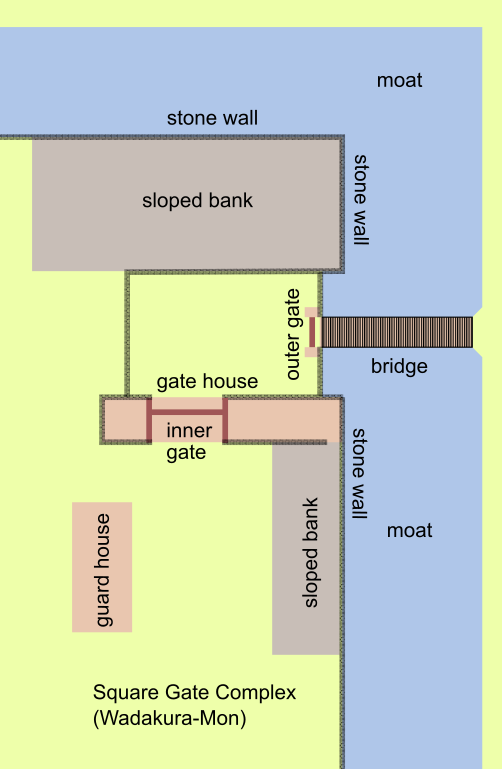
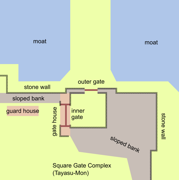
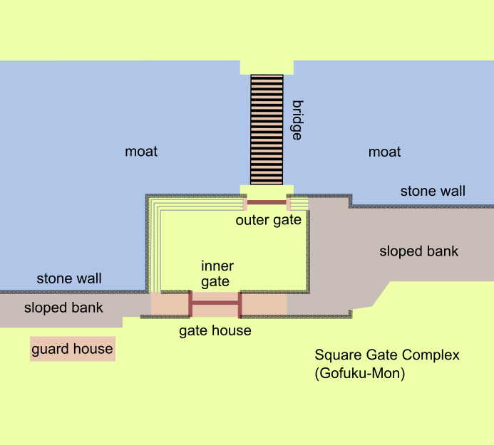
Like medieval European cities or citadels, Edo Castle was surrounded by multiple moats. Numerous bridges were built along with city gates. A typical city gate was equipped with a bridge, an outer gate, a square courtyard, and a gatehouse with an inner gate.
This gate complex resembled a barbican—a dual-gate structure common in medieval Europe, as well as Western and Eastern Asia. Enemies could easily cross the moat through the bridge and outer gate, but would then become trapped in the square courtyard, where they were surrounded and attacked by the defenders.
In Edo Castle, this style of gate structure was called a Mitsuke, which is classified into two types: L-shaped and S-shaped cranked entrances.
In an S-shaped Mitsuke, both gates face the same direction, but the passage bends at two points in between. In contrast, in an L-shaped cranked gateway, the inner and outer gates are positioned at a 90-degree angle. This design effectively stops enemy advances while occupying less space, making it the definitive form of the Mitsuke gate complex.
Mitsuke are also known as Masugata-Jomon (square-courtyard castle gates 枡形城門) or Masugata-Koguchi (square “tiger-mouth” entrances 枡形虎口). The term “tiger mouth” (koguchi) implies a highly dangerous point for invading enemies. The name Toranomon (Gate of the Tiger’s Mouth) reflects this exact concept.
- Asakusabashi 浅草橋
- Sujichigaibashi 筋違橋
- Koishikawa 小石川
- Ushigome 牛込
- Ichigaya 市ヶ谷
- Yotsuya 四谷
- Akasaka 赤坂
- Toranomon 虎ノ門
- Saiwaibashi 幸橋
- Yamashita 山下
- Sukiyabashi 数寄屋橋
- Kajiyabashi 鍛治屋橋
- Gofukubashi 呉服橋
- Tokiwabashi 常盤橋
- Kandabashi 神田橋
- Hitotsubashi 一ツ橋
- Kijibashi 雉子橋
- Shimizubashi 清水橋
- Tayasumon 田安門
- Hanzomon 半蔵門
- Sakuradamon 桜田門
- Hibiya 日比谷
- Babasakimon 馬場先門
- Wadakuramon 和田倉門
- Otemon 大手門
River Banks 河岸
- Uo-gashi 魚河岸
- Yaesu-gashi 八重洲河岸、八代州河岸
- Kamakura-gashi 鎌倉河岸
- Kuramae 蔵前
Rivers, Moats, Canals and Bridges
Kanda Hatchobori 神田八丁堀(Hiyoke-bori 火除堀、Ryukan-gawa 竜閑川)
- Ryukan-bashi 竜閑橋
- Shirahata-bashi 白旗橋
- Mondo-bashi 主水橋 (Nishi-nakanohashi 西仲之橋)
- Imagawa-bashi 今川橋
- Konyacho-bashi 紺屋町橋 (Higashi-nakanohasi 東仲之橋)
- Jizo-bashi 地蔵橋
- Hiyoke-bashi 火除橋
- Kudo-bashi 久道橋、九道橋
- Jinbe-bashi 甚兵衛橋
- Koide-bashi 小出橋